

The Map must be as true as the world
We are at the precise moment in history when the instruments of autonomous intelligence are only as sovereign as the cartographic foundations beneath them. Approximation is no longer a tolerable engineering posture.
“The question was never whether we could build a more accurate map. The question was whether we had the discipline to refuse anything less.”
Consider the architectural problem with extraordinary clarity: an autonomous system navigating at highway velocity must make irreversible decisions within margins of milliseconds, operating from a model of reality that was constructed, at some earlier moment, by instruments susceptible to light, shadow, precipitation, and signal attenuation.
LiDAR Point cloud generated by Genesys Constellation
HDmap+ by Genesys is built on LiDAR point cloud data—dense, disciplined, and mathematically sovereign.
HDmap+ by Genesys is built upon a cartographic philosophy fundamentally distinct from the prevailing orthodoxy. Its epistemological foundation is LiDAR point cloud data: a dense, georeferenced constellation of millions upon millions of three-dimensional measurements, each one a direct interrogation of the physical world at centimetre-level precision.
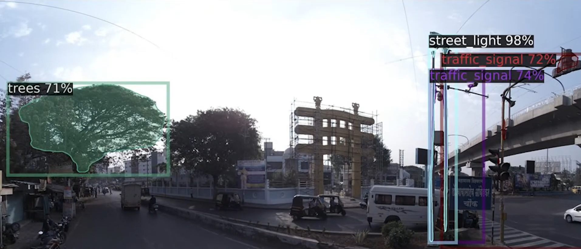
Every surface. Every lane boundary. Every curb and guardrail. Every overhead structure. Each is rendered not as an inference drawn from optical imagery, but as a geometric fact, a position in Euclidean space, verified, recorded, immutable.
LiDAR does not interpret. It does not infer. It measures the angle of incidence of a returning pulse and converts that measurement into a coordinate. The physics of this process are indifferent to the hour of day, the luminosity of the sky, or the density of precipitation in the air above the road. Shadows do not occlude it. Glare does not saturate it. Overcast skies do not diminish it.
What LiDAR Knows That Optics Cannot
The geometric integrity of a LiDAR point cloud is not a conditional property, it is a constitutional one. This distinction carries enormous consequences for those engineering perception systems, sensor fusion pipelines, and path planning architectures at the frontier of L2++ and more advanced ADAS.
For the OEM/Tier-1/ADAS-Stack/Ecosystem-partner integrating ADAS modules into production platforms, the map layer must not introduce uncertainty into a system already tasked with resolving it. The map is not the output of the system. The map is the ground truth against which all sensor outputs could be evaluated. Its fidelity is not a specification point. It is a prerequisite.
Three Obligations We Do Not Negotiate
Geometric Integrity, Without Exception
The point cloud does not degrade under adverse conditions. It does not produce phantom edges in low light or dissolve structural geometry in precipitation. The fidelity of HDmap+ is not weather-dependent. It is constitutionally stable, an engineering commitment, not a performance target.
Precision at the Stratum the Algorithm Demands
Sensor fusion algorithms are unforgiving evaluators. They do not accommodate a map whose precision is insufficient to distinguish lane boundaries from adjacent lane markings at merge points. HDmap+ delivers at the stratum where algorithmic confidence is built — not approximated toward, but achieved.
A Backbone Worthy of the Systems Above It
The map is the most foundational layer of autonomous intelligence. Whatever is built upon it, localization, predictive safety, path planning, behavioral modeling, inherits both its virtues and its inadequacies. We engineer the foundation as though everything depends on it. Because everything does.
This is not interpolation. It is measurement.
Optical systems are exquisite, but idiosyncratic. They are vulnerable to shadow, glare, low sun angles, monsoon haze. GPS is useful, yet intermittent. These are instruments of perception. LiDAR point clouds, by contrast, are instruments of geometry. They do not ask what the world appears to be. They describe what the world is.
That distinction is not academic. It is architectural.
For OEM/Tier-1/ADAS-Stack/Ecosystem-partner integrating ADAS modules, HDmap+ becomes a stabilizing reference frame, a geometric constant against which localization can converge with confidence. Sensor fusion becomes less speculative, more deterministic. Path planning becomes less reactive, more anticipatory. Predictive safety features operate within a terrain that is substantively anchored to ground truth.
For Automotive OEMs pursuing platform-scale autonomy, this is not a layer added at the periphery. It is the backbone. A high-fidelity spatial substrate that supports lane-level positioning, complex interchange choreography, and dense urban navigation without compounding uncertainty. When autonomy scales, error scales with it. Therefore precision must scale first.

Accuracy is not a feature appended at the end of a product cycle. It is engineered from the first pulse of the LiDAR.
We have chosen the slower, more exacting path- capturing the world in disciplined three-dimensional detail, because in automated driving, restraint is strength. The refusal to approximate is our competitive advantage. In a domain where machines assume responsibility, the only acceptable map is one that mirrors reality with unambiguous clarity.
The industry stands at an inflection point. ADAS is no longer an option package; it is the substrate of mobility’s future. Vehicles are evolving from mechanical assemblies into cognitive systems. And cognition demands a dependable spatial memory.
HDmap+ by Genesys is that memory.
When your systems must render judgment at highway speeds, “close enough” is an illusion. Centimeter-level certainty is the threshold.
We are not building maps. We are helping you build the geometric subconscious of automated driving.